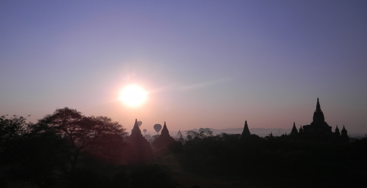
Just registered the domain name http://www.travelexpounded.com. Bear with us as we migrate the site over – if anyone has suggestions on how to expedite the process, that would be appreciated.
Will be back to posting travel updates soon.
Just registered the domain name http://www.travelexpounded.com. Bear with us as we migrate the site over – if anyone has suggestions on how to expedite the process, that would be appreciated.
Will be back to posting travel updates soon.
Techies can be people you really like or detest. Either they have a lot of answers (and hope that they explain these in a simple way) or they can get outright boring or arrogant by the way they are self centered and have the couldn’t care less attitude. But not all techies are nerds, some have a softer side to them. Here are some of the ways you can gain friends while traveling:

Offer to take photos for people who obviously can do better with someone doing it for them. With the dangerous situations people get themselves into while take selfies (not to mention the risks of getting hit by a selfie stick), photos still look best if taken by another person – provided that person knows how to take basic but interesting photos. And when taking photos – take at least two or three in different lighting scenarios so that the subjects can choose which of the photos they like. Always offer to do so with a smile, and show them proudly your photographic accomplishment. From that moment you will have won some degree of their trust and it is a good opportunity to make friends considering most people hang out at the same area while taking photos. And it works both ways – you get them to take your photo as well. Just don’t overextend the generosity and ask them to take 50 photos.
Offer to share your Wi-Fi connection if it is unlimited. This is one of the best ways to make people grateful to you, and it doesn’t cost much. Wi-Fi is still a limited resource in many countries and the person you offered free Wi-Fi to would likely have people back home that he or she is trying to keep updated so they don’t worry too much. You can do the same with smartphone tethering. Just make sure they don’t stream video or download malware because you’ll end up with more harm that good that was originally intended.
Bring a power strip or multiple USB charger when traveling. This works especially well at the airport where power outlets are in short supply. Some power strips have up to six or even twelve ports (the latter is too bulky for travel though), and some have USB chargers built in. And make sure your power cord is at least three to six feet long, so five of you won’t be crowding the outlet area while charging. Sometimes an extension cord of up to 10 feet will work, since that is also practical in some hotel rooms which have minimal power

outlets. By sharing the power, you get the opportunity to meet new friends as well. Just make sure you inform everyone way before you’re leaving so they can finish their charging until another generous soul with a power strip shows up after you’re gone.
Offer to find out a location using your mapping apps or Google Maps. Many travelers tend to get lost and confused especially in a place that they’ve been to for the first time. Even you as a first timer need not go through that issue. Aside from maps, there are tools on your tablet or smartphone that work in offline mode, so you don’t have to use your data plan to incur costs. Saving somebody a few minutes and the headache of getting to their destination is a big deal. And yes, make sure they understand exactly how to navigate there or at least have a visual idea of where they are headed.

During my travels I have learned that sharing is good, and you don’t need to obligate people to return the favor. I have made quite a few purchases like Wi-Fi hotspots, multi-USB chargers and the like in the past few years after having learned what I need to bring while traveling to be efficient. Sharing techie resources freely in addition to some skills like photography, direction giving, even a common resource like power is bound to make people grateful to you, and in good cases, strike up a conversation and add a new friend.
Let’s face it. Sometimes we make purchases because the prices are too low to resist, and missing out on the opportunity is something we cannot imagine doing. This goes for most aspects of travel, starting with airplane flights, train tickets, travel gear and even travel clothing.
How many times have you seen people who buy brand new but generic suitcases, only to see it fall apart upon first use? Or those with cheap zippers than can be opened by an ordinary ballpen? Or one which wheels fall apart the moment it hits rough roads for a few hundred meters?
Just like any acquisition (house, car), we have to look beyond the initial purchase cost. A backpack may cost you under a hundred dollars but you end up replacing it every two years or less (or even after one heavy use). Buy a high quality piece of luggage at 3-4x the cost but it will last you ten years or even more. In the long run, the latter option comes out twice cheaper. Some people buy luggage as if it were a disposable commodity. Sure, and they also add to the clogging of landfills once they get tired of the bag and throw it into the garbage bin. And they are not helping the environment in any way.
If you can use recyclable items, the better for your pocket and the environment. Sometimes the recyclable items will cost double those of regular items. But also these may come with a really good warranty or they are highly durable that there is no need for a warranty during the first few years. And not only that – you usually purchase from a manufacturer whose concern for the environment results in them supporting a worthy project, or they regular donate and participate in earth saving activities and initiatives.
I can start off with appliances, cars and the like but for travel we always start with the bag. Surprisingly, my first advice is not to immediately buy any luggage – have you considered borrowing from family or friends who regularly travel? With a trip to borrow the item comes a good opportunity to catch up with them. They will also be able to tell you tips on how to maximize packing, what carrying style works for them, and so on.
Once you have made a few trips and anticipate a lot more on your own, then it is time to search and purchase the best luggage that will suit you for the next decade or two.
Essentially luggage can be classified as wheeled or carry-able by a strap or straps. We shall save the discussion about carry-on vs. checked-in luggage for another time. What are the advantages and disadvantages of wheeled versus carried luggage?
Wheeled luggage takes the strain off your back and is good for traveling where a lot of walking is involved – at the terminal, within the hotel, on the street, wherever there is a flat and relatively even surface to drag the luggage behind you. Many types of luggage come with inline skates types of wheels, which glide smoothly and are fairly durable. A variation of wheeled luggage that has become popular the past decade is the spinner wheel system, which is four sets of wheels that rotate completely in any direction but will generally allow the luggage to be pushed forward on all four wheels. It can also be used in the traditional two wheel pulling setup, but that method puts strain on the person’s wrist. With all spinner wheels rolling on the ground, the strain is taken off and another small carryon can be added to the setup with minimal effort. No wonder these have become very popular with travelers, thanks to the ease of transport.
The other method is the carry with via straps or handles. This was how suitcases were made for many decades, and it is practical for light loads. The moment the load goes over 20 lbs it is already a big strain on the wrist and shoulders. Not only that, because your hands are preoccupied with the handles, it would be hard to lash an additional bag for carrying. This method is practical only for light loads where travel is expected to be no more than 3 days.
And we also have the backpack. This is an ingenious way of carrying all of the load on your back with the weight on the hips for stability. It also allows faster movement within crowds at the airport, as you’re not bumping your luggage into someone else’s. However, it is also inconvenient to transport when loads are heavy, not to mention the strain on your back if it is not properly packed or balanced. Advantages of the backpack are the ability to free up both hands to carry an additional small bag, or for handling other chores while not worrying about the bag being away from you. Of course, not seeing what is behind you can also be a risk for theft especially if your backpack is not properly secured with a lock.

Over the years, I have come to find my ideal piece of luggage – a 25” rolling backpack manufactured by Eagle Creek, the Switchback™ Max. It combines a two wheeled luggage with shoulder straps that allow it to be carried as a backpack, yet it also has a handle which allows it to be pulled like any other wheeled bag. Plus it has a zipper detachable daypack, which can be carried around your destination with the basic necessities for a day of exploring town. What is nice about my Switchback™ is that it has one of the best warranties in the planet – they will replace or repair it free of charge using the “No Matter What™” warranty. So far, it’s been more than four years since I’ve had this and there has been no need whatsoever to replace or fix anything – and I’ve done almost every trip since then with this luggage!
Sure, it costs three to four times more than an average backpack – but I am sure it will probably last five times longer. One of my Spinner luggage has gone more than ten years before the first rubber wheel broke, and the construction build isn’t as sturdy as the Switchback™. I am anticipating I will have my Switchback™ for more than 15 years – and probably if it doesn’t last by then, it would have been replaced with a similar product due to the extensive warranty.

When I was a young boy, our house was located beside the railroad tracks in a compound which housed a sugarcane factory. Every morning I could hear the chugging of the steam locomotives hauling sugarcane all the way to the sugar mill. These trains dated back to the 1920s and were still operational in the 1980s until they were replaced by diesel locomotives. Of course, these were not passenger trains so it would take a while before I actually rode a real train (and this doesn’t count the ones in Disneyland and other theme parks!)
Passenger trains are classified in many ways – but one way of dividing them is by the gauge of the rail tracks. Narrow gauge (commonly used in Japan, some parts of Asia, Africa and Ocenia) is usually about 1,000-1,067mm wide and allows for speeds a little over 100kph. These are usually the British influenced territories that have gained independence since the 1940s (Southern Africa, New Zealand, Indonesia). “Standard” gauge is the most dominant in many geographical regions, and is generally understood to be 1,435 mm (4 ft 8 1⁄2 in). Most of Europe, the USA, Canada, China and Australia use standard gauge and these are suitable for high speed trains like the TGV, Acela, some Shinkansen lines, and most light rail or subway lines). Then you have extremes like 7+ foot wide track gauges in Brunei. India and the former U.S.S.R. countries also have their own gauges, usually wider than 5 feet. Just like a car, the wider the distance between the wheels, the lower the center of gravity and smoother the ride.


I have been fascinated with maps since I was very young. My parents had this large Atlas by National Geographic from the late 60’s (probably the First or Second Edition), which we have kept until it became worn and tattered. During those days Africa was mostly known for the countries still in colonial rule, and even countries which were non-existent were still part of another country whose name is gone from the schoolbooks already (think Rhodesia, Tanganyika, Dahomey, Upper Volta and others). Even Asian countries like Sri Lanka and Myanmar were known by their colonial names (Ceylon and Burma – although many people still refer to Myanmar as Burma up to now).
In grade school we were also taught about the 50 U.S. states and their capitals – I still remember them up to now, even the way the were positioned on the map. I’d start off reciting the New England States (Maine, New Hampshire, Vermont, and so on), continue with the states on the Eastern Seaboard, move into the Midwest and South, then the Rockies, then the Pacific, finally topping these off with Alaska and Hawaii. Not to mention territories too … Guam and Saipan came to mind.
One of my Favorite games on Facebook is Traveler IQ challenge, where you try to pin the city in a blank world map and depending on how close you are to the actual longitude and latitude coordinates, you get higher points. I managed to score at the top of my friends list, even though it’s been more than a year since I last played it.
Whenever I travel one of the first things I do upon arriving at the airport is to look for the free maps – something I’ve been doing since the early 90s. And I always get 2 – one for actually navigation and writing on (that gets folded and crumpled and eventually thrown away when torn) and another one for filing purposes which I use to study in case I return to that destination. Since I traveled often to Singapore I had at one time so many Singapore free maps, that I usually give away one to a friend who would be visiting Singapore soon. It’s definitely a way of keeping informed and being helpful to fellow travelers at the same time.
Now that mapping applications have gone onto the web and as smartphone/tablet apps, I always have at least three of them in my iPhone/iPad. The most utilized are:
I love PocketEarth for the ability to be used offline, although the full world map that is zoomable is over 14GB in size – even my 64GB iPhone has challenges keeping all the maps so I just download individual regions when I travel. These maps are best viewed on a tablet for zooming in purposes, but often you need them on your smartphone for navigation purposes. Pocket Earth also embeds wikipedia articles in points of interest (POI) that are saved offline, which explains the huge file size. Nevertheless, these are useful enough to warrant occupying over 5% of my iPhone space for each app.
Even if I were to be stuck in a place for many hours, I can manage to keep my imagination alive given these maps, whether static or online.
Have you ever wondered what places you visited on your last trip? Like where you were, how long you stayed there, and where you went to next? Or even down to the detail of the time and duration you were actually there? Sounds too complicated for our memories to remember the specifics. But there is a way of documenting it, down to a fairly accurate illustration using Google Maps.
Google recently rolled out “Your Timeline”, which is a new feature of Google Maps that allows viewing of the recent places you’ve visited (provided you were logged on to Google Maps then). It allows you to see the route you took on a road trip, and the exact address if you used a search plus navigation for directions on how to get to your destination. If you checked into a place, a clickable icon will display details and even the duration of your stay. It is like an online journal that keeps track of your movements between destinations.
I have used Google maps primarily for searching and navigation to places I have never been to for the first time. It has its own voice guidance, which can be quite persistent. On a recent roadtrip to San Diego I had to disable Google Maps from time to time because it was reminding me to “turn right, turn left in so and so meters”… and was competing for airtime with my Garmin GPS and another app running on my phone, which was Waze. But it definitely helpful for searching where we were, how far we were, and how many hours and minutes to the next waypoint. That alone made it useful, not to mention the journaling ability which the GPS and Waze do not have (although Waze was bought by Google a couple of years back for a cool $1.3 billion so they would have incorporated similar features sooner or later).
Your Timeline is available on the desktop, as well as Android devices. Not sure if and when they will make that available for iOS devices as Apple has its own competing Maps app. But it certainly suits me well – with a locked iPhone to the telco providers here, I make sure I bring my Android smartphone an link it with a local SIM in the country I’m traveling to so I get to use this neat feature of Google Maps.
As this feature is activated by use of your mobile device, only you using your Google login can see it. You can also choose to pause reporting your location history if you find it too much of an Orwellian “Big Brother”. I generally use it when traveling and it helps in providing those details to my blog, or even during conversations that reminisce the great trips I’ve taken.
Thanks to social media, reliving memories of your turn-by-turn travels is just a matter of logging on to your Google account!
Over 80 years ago a cartoon character in a yellow trench coat was created. For those of you who don’t know Dick Tracy, he was the police detective famous for his wrist radio, likely the inspiration for today’s Apple Watch. Back then Dick Tracy could call his police counterparts on his wrist radio and they will track and capture the criminals all with the use of high technology and gadgets. To the point of tracking them as they were on the loose. Nowadays, you don’t need Dick Tracy to track down your friends or even have yourself tracked down – all you need are apps on the smartphone that use GPS and your permission to do so.
Tracking friends serves many purposes, and they are not always of the crime fighting kind. For example, you and your friends or acquaintances are all going to meet up at a place where you’ve never been before, and don’t know long it will take to get there. With the use of Google Maps, Four Square or some other mapping software to locate the place, you now have a general idea of where to go. Google Maps even will allow you using its directions feature turn-by-turn instructions on arriving at the destination, with estimated travel times by car, bus, train or even walking! To carry it a step further, the popular car mapping app Waze will even use crowdsourcing to estimate your arrival time, and adjust it accordingly when traffic piles up. And it will even give you alternate routes in case your preferred route is packed with traffic. Another app I also use is Glympse, which allows you to send anyone via email or SMS a link to a map which they can open in their computer or smartphone browser – and it even tells you how fast you’re moving together with a path leading to the destination.
A very good use of tracking apps is to keep tabs on your family, especially the children. Apple has free apps such as Find My Friends which allow each other to track via GPS phone contacts who agree to have the app itself monitor their location. You have to opt in, meaning, sign up and confirm with your Apple ID and those who have the same app will now be able to see you on a map grid anywhere in the world where there is connectivity (and vice-versa). This comes handy not to stalk people but really more to get an idea in which vicinity they are located in. This also ties into a feature called “Find my iPhone” which is a locator for your iOS devices, in case you misplace them or these are stolen. Again, depending on the permissions you allow in the settings of your smartphone or app account, you can track as much as you want or up to an assigned time period. People have to be asked permission before they are tracked, but devices that are yours don’t need to. GPS even goes further beyond to allow for tracking pets, vehicles, setting up a geofence, and so on – but we will save that for another update.
Nice way to track, but what about privacy issues? These apps would normally require access to your location via location services on your phone settings, but you can instruct these to allow sharing for a particular time (as with Glympse), or until you reach the destination (Waze), or also by disabling access manually (Google Maps and the rest). Because location services uses a lot of battery power, it makes sense to disable them once there is no need. Waze offers an interesting view as you see all those who have sent their location info move and converge at the destination. This is quite handy as an organizer of an event.
Because of the numerous business opportunities allowed by location based services, companies are racing to develop apps that allow spot advertising as well as hailing transportation on demand. We will discuss in the future how these have allowed companies like Uber to leverage a need while using a well developed app that covers reservations, tracking and payment in our daily commutes.
In the meantime, where is Dick Tracy now? His radio seems to be having lots of static …
The Traveler’s Century Club (TCC) is one of the older travel clubs formed when overseas traveling was a luxury for most humans. Formed back in 1959, most travel was via propeller planes and sailing liners – traveling by land wouldn’t get you more than 20 or so countries, unless you were in the European continent. Asia back then was hard to travel because of colonies that had just become independent, or the sheer lack of transport facilities between countries.
Fast forward to the jet age and especially the dawn of the low-cost carriers (LCCs) – people who would normally be able to travel to more than 20 countries would be much younger, more mobile, and not necessarily rich to be able to do so. But still 100 countries or territories is no easy feat. Hence this group of distinguished travelers is still one of the most prestigious clubs one can aspire for.
Note that some countries like the USA and Indonesia will have up to 3 or more places listed that qualify as a territory aside from the country itself (e.g. Hawaii, Alaska). Hence to complete the list one need not go to 100 U.N. recognized countries (I have been to 29). Just a tad short, maybe 90 countries plus 10 territories would make you qualified for membership to the TCC.
My list of territories and countries visited for the Travelers’ Century Club: (almost a third already).
The full list of countries and territories is found here – Geographic Directory of TCC Countries & Territories

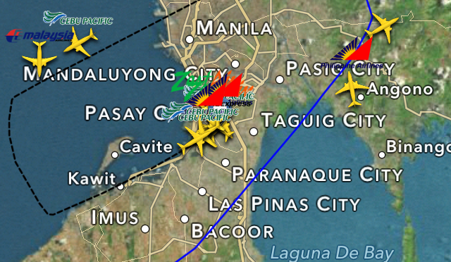
Tracking an airplane flight in real time. Sounds like something out of a James Bond thriller (Roger Moore era). But now with technology, tracking an actual flight from departure to landing is something most of us can do for free. And for those who want more details, a few more dollars will certainly get a very useful app you can use on your smartphone.
There are two particular websites I use when tracking flights, and a couple more apps. These are FlightRadar24 and FlightAware. I am more biased towards FlightRadar24 as it has a livelier display and the apps on the phone are equally sufficient in terms of providing content compared to the website. FlightAware, on the other hand, has a lively forum and markets other products in addition to its apps and website.

Flights are tracked using automatic dependent surveillance broadcast (ADS-B), and even the FAA (although delayed by about 5 minutes). While the airplane gets its coordinates from a GPS satellite, it also sends a signal via transponder containing the location information which is picked up by a receiver. That receiver then forwards the information to a website which aggregrates this information (flightradar24 is one such site). Then the information is posted on the web for all who have access to the site to see. A more thorough explanation is provided here – http://www.flightradar24.com/how-it-works
I have used FlightRadar24 and FlightAware for over two years now and these are the reasons and benefits I gain from doing so:
1. Checking if someone’s flight has already arrived at the airport – or in case of delay, how to estimate their arrival. This is important when I pick up people from the airport in MNL because of traffic and parking issues. If I arrive too early, some airport terminals won’t allow me to park at all thus I end up going around the vicinity and wasting fuel. Together with traffic apps such as Waze, I am able to estimate the time I need to leave in order to minimize the wait of both parties at the terminal. Not to mention this is more reliable than some airlines’ and airports’ websites which don’t provide arrival or departure information until hours after the event has taken place. Likewise, I don’t need to call the reservations office because they will also likely be in the dark as to the actual arrival time.
2. Seeing the actual flight path of the airplane. While pilots always have a flight plan, they don’t stick to this 100%. And most flight plans are kept in secrecy for safety and security reasons. But once the flight is airborne, they can’t do without transmitting via transponder their location. It is interesting to note how what we think is the most direct route is nowhere near the actual flight pattern. You can also use this information to determine which countries the plane has flown over in terms of airspace, and the more complicated things like how overflight time is computed is considered an interesting topic by the most geeky of aviation enthusiasts.
3. Estimating the return flight. Many flights do a turn-around within the same day, meaning not all planes stay overnight at the destination airport. Thus the plane that will arrive is generally going to be the outbound flight back to the origin (or in some cases, another transit point). If your incoming plane on a different flight number is delayed, chances are that your flight out will be delayed as well. Thus you can use this information to notify people in advance that you may arrive later than usual, especially if the flight is a short inter-island hop (less than 2 hours). In cases of long haul flights, pilots can compensate by flying faster so they will still manage to arrive at their destination within a few minutes of schedule even if the flight was delayed by up to an hour or two.
I have at least a couple of friends who use these flight trackers aside from me – and they have used this information to keep tabs on people flying into a city for a organized travel group meetup, while informing the rest of who have already arrived and are on the way to the hotel and meetup venue.
In an upcoming post I will discuss how one can allow others to track his/her location (with permission, of course!)